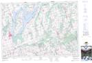
Maps showing Mississauga's of Scugog Island, Durham, Ontario
Mississauga's of Scugog Island is a Indian Reserve located in Durham, Ontario.
- Latitude: 44° 11' 11'' North (decimal: 44.1863888)
- Longitude: 78° 53' 17'' West (decimal: -78.8880555)
- Topography Feature Category: Indian Reserve
- Geographical Feature: Indian Reserve - Réserve indienne
- Canadian Province/Territory: Ontario
- Location: Durham
- Atlas of Canada Locator Map: Mississauga's of Scugog Island
- GPS Coordinate Locator Map: Mississauga's of Scugog Island Lat/Long