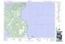
Maps showing Saugeen and Cape Croker Fishing Islands 1, Bruce, Ontario
Saugeen and Cape Croker Fishing Islands 1 is a Indian Reserve located in Bruce, Ontario.
- Latitude: 45° 10' 53'' North (decimal: 45.1813888)
- Longitude: 81° 29' 23'' West (decimal: -81.4897221)
- Topography Feature Category: Indian Reserve
- Geographical Feature: Indian Reserve - Réserve indienne
- Canadian Province/Territory: Ontario
- Location: Bruce
- Atlas of Canada Locator Map: Saugeen and Cape Croker Fishing Islands 1
- GPS Coordinate Locator Map: Saugeen and Cape Croker Fishing Islands 1 Lat/Long
Saugeen and Cape Croker Fishing Islands 1 NTS Map Sheets