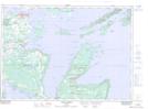
Maps showing Sucker Creek 23, Manitoulin, Ontario
Sucker Creek 23 is a Indian Reserve located in Manitoulin, Ontario.
- Latitude: 45° 57' 41'' North (decimal: 45.9613888)
- Longitude: 81° 59' 47'' West (decimal: -81.9963888)
- Topography Feature Category: Indian Reserve
- Geographical Feature: Indian Reserve - Réserve indienne
- Canadian Province/Territory: Ontario
- Location: Manitoulin
- Atlas of Canada Locator Map: Sucker Creek 23
- GPS Coordinate Locator Map: Sucker Creek 23 Lat/Long
Sucker Creek 23 NTS Map Sheets