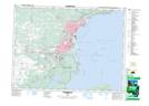
Maps showing Fort William 52, Thunder Bay, Ontario
Fort William 52 is a Indian Reserve located in Thunder Bay, Ontario.
- Latitude: 48° 18' 59'' North (decimal: 48.3163888)
- Longitude: 89° 16' 14'' West (decimal: -89.2705555)
- Topography Feature Category: Indian Reserve
- Geographical Feature: Indian Reserve - Réserve indienne
- Canadian Province/Territory: Ontario
- Location: Thunder Bay
- Atlas of Canada Locator Map: Fort William 52
- GPS Coordinate Locator Map: Fort William 52 Lat/Long
Fort William 52 NTS Map Sheets