Maps showing Henvey Inlet 2, Parry Sound, Ontario
Henvey Inlet 2 is a Indian Reserve located in Parry Sound, Ontario.
- Latitude: 45° 51' 21'' North (decimal: 45.8558333)
- Longitude: 80° 37' 46'' West (decimal: -80.6294443)
- Topography Feature Category: Indian Reserve
- Geographical Feature: Indian Reserve - Réserve indienne
- Canadian Province/Territory: Ontario
- Location: Parry Sound
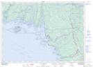
- Atlas of Canada Locator Map: Henvey Inlet 2
- GPS Coordinate Locator Map: Henvey Inlet 2 Lat/Long
Henvey Inlet 2 NTS Map Sheets