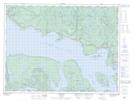
Maps showing Pays Plat, Thunder Bay, Ontario
Pays Plat is a Unincorporated area located in Thunder Bay, Ontario.
- Latitude: 48° 52' 58'' North (decimal: 48.8827776)
- Longitude: 87° 33' 25'' West (decimal: -87.5569443)
- Topography Feature Category: Unincorporated area
- Geographical Feature: Community
- Canadian Province/Territory: Ontario
- Location: Thunder Bay
- Atlas of Canada Locator Map: Pays Plat
- GPS Coordinate Locator Map: Pays Plat Lat/Long