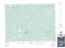
Maps showing Campfire Island (39), Strathcona, Ontario
Campfire Island (39) is a Island located in Strathcona, Ontario.
- Latitude: 47° 3' 26'' North (decimal: 47.057169)
- Longitude: 79° 48' 19'' West (decimal: -79.805329)
- Topography Feature Category: Island
- Geographical Feature: Island
- Canadian Province/Territory: Ontario
- Location: Strathcona
- Atlas of Canada Locator Map: Campfire Island (39)
- GPS Coordinate Locator Map: Campfire Island (39) Lat/Long
Campfire Island (39) NTS Map Sheets