Maps showing Dragonfly Island, Ontario
Dragonfly Island is a Island located in Ontario.
- Latitude: 48° 45' 7'' North (decimal: 48.751847)
- Longitude: 93° 20' 33'' West (decimal: -93.3424048)
- Topography Feature Category: Island
- Geographical Feature: Island
- Canadian Province/Territory: Ontario
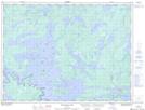
- Atlas of Canada Locator Map: Dragonfly Island
- GPS Coordinate Locator Map: Dragonfly Island Lat/Long
Dragonfly Island NTS Map Sheets