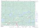
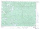
Maps showing Flat Creek Old Pine Conservation Reserve, Sudbury, Ontario
Flat Creek Old Pine Conservation Reserve is a Conservation area located in Sudbury, Ontario.
- Latitude: 46° 28' 30'' North (decimal: 46.4750000)
- Longitude: 81° 60' 00'' West (decimal: -81.9999999)
- Topography Feature Category: Conservation area
- Geographical Feature: Conservation Reserve
- Canadian Province/Territory: Ontario
- Location: Sudbury
- Atlas of Canada Locator Map: Flat Creek Old Pine Conservation Reserve
- GPS Coordinate Locator Map: Flat Creek Old Pine Conservation Reserve Lat/Long
Flat Creek Old Pine Conservation Reserve NTS Map Sheets