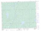
Maps showing Strickland River Mixed Forest Wetland Conservation Reserve, Algoma, Ontario
Strickland River Mixed Forest Wetland Conservation Reserve is a Conservation area located in Algoma, Ontario.
- Latitude: 48° 46' 30'' North (decimal: 48.7749999)
- Longitude: 84° 55' 0'' West (decimal: -84.9166999)
- Topography Feature Category: Conservation area
- Geographical Feature: Conservation Reserve
- Canadian Province/Territory: Ontario
- Location: Algoma
- Atlas of Canada Locator Map: Strickland River Mixed Forest Wetland Conservation Reserve
- GPS Coordinate Locator Map: Strickland River Mixed Forest Wetland Conservation Reserve Lat/Long
Strickland River Mixed Forest Wetland Conservation Reserve NTS Map Sheets