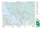
Maps showing Wahta, GIBSON, Ontario
Wahta is a Unincorporated area located in GIBSON, Ontario.
- Latitude: 44° 59' 32'' North (decimal: 44.9921198)
- Longitude: 79° 43' 45'' West (decimal: -79.7291389)
- Topography Feature Category: Unincorporated area
- Geographical Feature: Dispersed Rural Community
- Canadian Province/Territory: Ontario
- Location: GIBSON
- Atlas of Canada Locator Map: Wahta
- GPS Coordinate Locator Map: Wahta Lat/Long
Wahta NTS Map Sheets