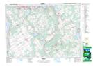
Maps showing Waubaushene Beaches Provincial Park, Tay, Ontario
Waubaushene Beaches Provincial Park is a Conservation area located in Tay, Ontario.
- Latitude: 44° 44' 53'' North (decimal: 44.74805)
- Longitude: 79° 43' 12'' West (decimal: -79.7200398)
- Topography Feature Category: Conservation area
- Geographical Feature: Provincial Nature Reserve
- Canadian Province/Territory: Ontario
- Location: Tay
- Atlas of Canada Locator Map: Waubaushene Beaches Provincial Park
- GPS Coordinate Locator Map: Waubaushene Beaches Provincial Park Lat/Long
Waubaushene Beaches Provincial Park NTS Map Sheets