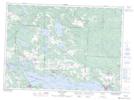
Maps showing Galbraith Peatland Conservation Reserve, Galbraith, Ontario
Galbraith Peatland Conservation Reserve is a Conservation area located in Galbraith, Ontario.
- Latitude: 46° 28' 26'' North (decimal: 46.473786)
- Longitude: 83° 39' 4'' West (decimal: -83.651121)
- Topography Feature Category: Conservation area
- Geographical Feature: Conservation Reserve
- Canadian Province/Territory: Ontario
- Location: Galbraith
- Atlas of Canada Locator Map: Galbraith Peatland Conservation Reserve
- GPS Coordinate Locator Map: Galbraith Peatland Conservation Reserve Lat/Long
Galbraith Peatland Conservation Reserve NTS Map Sheets