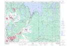
Maps showing Garson Forest Conservation Reserve, Garson, Ontario
Garson Forest Conservation Reserve is a Conservation area located in Garson, Ontario.
- Latitude: 46° 37' 1'' North (decimal: 46.617029)
- Longitude: 80° 50' 30'' West (decimal: -80.841588)
- Topography Feature Category: Conservation area
- Geographical Feature: Conservation Reserve
- Canadian Province/Territory: Ontario
- Location: Garson
- Atlas of Canada Locator Map: Garson Forest Conservation Reserve
- GPS Coordinate Locator Map: Garson Forest Conservation Reserve Lat/Long