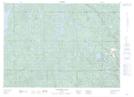
Maps showing Botha Creek, Sudbury, Ontario
Botha Creek is a River located in Sudbury, Ontario.
- Latitude: 46° 56' 10'' North (decimal: 46.9361111)
- Longitude: 81° 16' 37'' West (decimal: -81.2769443)
- Topography Feature Category: River
- Geographical Feature: Creek
- Canadian Province/Territory: Ontario
- Location: Sudbury
- Atlas of Canada Locator Map: Botha Creek
- GPS Coordinate Locator Map: Botha Creek Lat/Long
Botha Creek NTS Map Sheets