Canada Topographic Maps

Point Asham Topo Maps

Topography maps and Latitude/Longitude Location

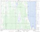
Maps showing Point Asham, Manitoba

Point Asham is a Cape located in Manitoba.

  • Latitude: 51° 18' 8'' North   (decimal: 51.3022000)
  • Longitude: 99° 2' 32'' West   (decimal: -99.0422000)
  • Topography Feature Category: Cape
  • Geographical Feature: Point
  • Canadian Province/Territory: Manitoba
  • GPS Coordinate Locator Map: Point Asham Lat/Long

Point Asham NTS Map Sheets

062O06 Cayer Topographic Map at 1:50,000 scale

062O Dauphin Lake Topographic Map at 1:250,000 scale

 
Buy Topographic Maps DVD
Newsletter Sign-up

Yes, I want to receive map store discounts.


Bookmark and Share