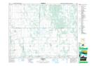
Maps showing Black Poplar Bluff Lake, 3,10-20-12-W, Manitoba
Black Poplar Bluff Lake is a Lake located in 3,10-20-12-W, Manitoba.
- Latitude: 50° 41' 53'' North (decimal: 50.6980999)
- Longitude: 99° 2' 56'' West (decimal: -99.0488999)
- Topography Feature Category: Lake
- Geographical Feature: Lake
- Canadian Province/Territory: Manitoba
- Location: 3,10-20-12-W
- Atlas of Canada Locator Map: Black Poplar Bluff Lake
- GPS Coordinate Locator Map: Black Poplar Bluff Lake Lat/Long