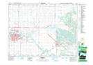
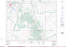
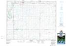
Maps showing Boggy Creek, 33-14-15-W, Manitoba
Boggy Creek is a River located in 33-14-15-W, Manitoba and has an elevation of 378 meters.
- Latitude: 50° 13' 42'' North (decimal: 50.2283000)
- Longitude: 99° 27' 21'' West (decimal: -99.4558000)
- Topography Feature Category: River
- Geographical Feature: Creek
- Canadian Province/Territory: Manitoba
- Elevation: 378 meters
- Location: 33-14-15-W
- Atlas of Canada Locator Map: Boggy Creek
- GPS Coordinate Locator Map: Boggy Creek Lat/Long
Boggy Creek NTS Map Sheets