Maps showing Cleghorn Hill, 35-16-27-W;2-17-27-W, Manitoba
Cleghorn Hill is a Mountain located in 35-16-27-W;2-17-27-W, Manitoba and has an elevation of 490 meters.
- Latitude: 50° 24' 53'' North (decimal: 50.4147000)
- Longitude: 101° 5' 44'' West (decimal: -101.0955999)
- Topography Feature Category: Mountain
- Geographical Feature: Hill
- Canadian Province/Territory: Manitoba
- Elevation: 490 meters
- Location: 35-16-27-W;2-17-27-W
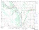
- Atlas of Canada Locator Map: Cleghorn Hill
- GPS Coordinate Locator Map: Cleghorn Hill Lat/Long
Cleghorn Hill NTS Map Sheets