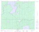
Maps showing Cotes Landing, Manitoba
Cotes Landing is a Unincorporated area located in Manitoba.
- Latitude: 54° 38' 53'' North (decimal: 54.6481000)
- Longitude: 99° 47' 31'' West (decimal: -99.7919000)
- Topography Feature Category: Unincorporated area
- Geographical Feature: Locality
- Canadian Province/Territory: Manitoba
- Atlas of Canada Locator Map: Cotes Landing
- GPS Coordinate Locator Map: Cotes Landing Lat/Long
Cotes Landing NTS Map Sheets