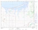
Maps showing Dans Slough, 21-14-5-W, Manitoba
Dans Slough is a Low vegetation located in 21-14-5-W, Manitoba.
- Latitude: 50° 12' 13'' North (decimal: 50.2035999)
- Longitude: 98° 5' 38'' West (decimal: -98.0939000)
- Topography Feature Category: Low vegetation
- Geographical Feature: Slough
- Canadian Province/Territory: Manitoba
- Location: 21-14-5-W
- Atlas of Canada Locator Map: Dans Slough
- GPS Coordinate Locator Map: Dans Slough Lat/Long