Maps showing Dauphin, Manitoba
Dauphin is a Other municipal/district area - miscellaneous located in Manitoba.
- Latitude: 51° 11' 45'' North (decimal: 51.1958000)
- Longitude: 100° 3' 45'' West (decimal: -100.0625000)
- Topography Feature Category: Other municipal/district area - miscellaneous
- Geographical Feature: Rural Municipality
- Canadian Province/Territory: Manitoba
- Atlas of Canada Locator Map: Dauphin
- GPS Coordinate Locator Map: Dauphin Lat/Long
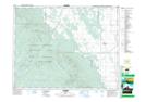
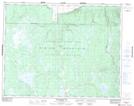
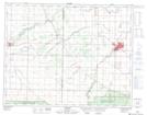
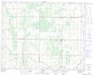
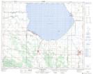
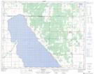
Dauphin NTS Map Sheets
062J13 Laurier Topographic Map at 1:50,000 scale
062K16 Whitewater Lake Topographic Map at 1:50,000 scale
062N01 Dauphin Topographic Map at 1:50,000 scale
062N08 Sifton Topographic Map at 1:50,000 scale
062O04 Ochre River Topographic Map at 1:50,000 scale
062O05 Rorketon Topographic Map at 1:50,000 scale
062J Neepawa Topographic Map at 1:250,000 scale
062K Riding Mountain Topographic Map at 1:250,000 scale
062N Duck Mountain Topographic Map at 1:250,000 scale
062O Dauphin Lake Topographic Map at 1:250,000 scale