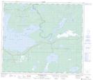
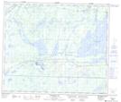
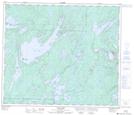
Maps showing Four Mile Portage, 66,67-20,21-W, Manitoba
Four Mile Portage is a Road feature located in 66,67-20,21-W, Manitoba and has an elevation of 294 meters.
- Latitude: 54° 44' 56'' North (decimal: 54.7488999)
- Longitude: 100° 28' 54'' West (decimal: -100.4817000)
- Topography Feature Category: Road feature
- Geographical Feature: Portage
- Canadian Province/Territory: Manitoba
- Elevation: 294 meters
- Location: 66,67-20,21-W
- Atlas of Canada Locator Map: Four Mile Portage
- GPS Coordinate Locator Map: Four Mile Portage Lat/Long
Four Mile Portage NTS Map Sheets