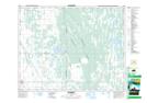
Maps showing Glenhope Lake, 21-14-W, Manitoba
Glenhope Lake is a Lake located in 21-14-W, Manitoba and has an elevation of 298 meters.
- Latitude: 50° 47' 47'' North (decimal: 50.7964000)
- Longitude: 99° 16' 59'' West (decimal: -99.2831000)
- Topography Feature Category: Lake
- Geographical Feature: Lake
- Canadian Province/Territory: Manitoba
- Elevation: 298 meters
- Location: 21-14-W
- Atlas of Canada Locator Map: Glenhope Lake
- GPS Coordinate Locator Map: Glenhope Lake Lat/Long