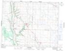
Maps showing Grays Lake, 9,16,17-20-28-W, Manitoba
Grays Lake is a Lake located in 9,16,17-20-28-W, Manitoba and has an elevation of 549 meters.
- Latitude: 50° 43' 9'' North (decimal: 50.7192000)
- Longitude: 101° 18' 40'' West (decimal: -101.3111000)
- Topography Feature Category: Lake
- Geographical Feature: Lake
- Canadian Province/Territory: Manitoba
- Elevation: 549 meters
- Location: 9,16,17-20-28-W
- Atlas of Canada Locator Map: Grays Lake
- GPS Coordinate Locator Map: Grays Lake Lat/Long
Grays Lake NTS Map Sheets