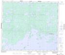
Maps showing Johnson Bay, Manitoba
Johnson Bay is a Bay located in Manitoba and has an elevation of 187 meters.
- Latitude: 54° 50' 27'' North (decimal: 54.8408000)
- Longitude: 94° 12' 24'' West (decimal: -94.2067000)
- Topography Feature Category: Bay
- Geographical Feature: Bay
- Canadian Province/Territory: Manitoba
- Elevation: 187 meters
- Atlas of Canada Locator Map: Johnson Bay
- GPS Coordinate Locator Map: Johnson Bay Lat/Long
Johnson Bay NTS Map Sheets