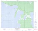
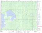
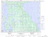
Maps showing Kaweenakumik Lake, 44,45-14,15-W, Manitoba
Kaweenakumik Lake is a Lake located in 44,45-14,15-W, Manitoba and has an elevation of 267 meters.
- Latitude: 52° 49' 59'' North (decimal: 52.8331000)
- Longitude: 99° 30' 1'' West (decimal: -99.5003000)
- Topography Feature Category: Lake
- Geographical Feature: Lake
- Canadian Province/Territory: Manitoba
- Elevation: 267 meters
- Location: 44,45-14,15-W
- Atlas of Canada Locator Map: Kaweenakumik Lake
- GPS Coordinate Locator Map: Kaweenakumik Lake Lat/Long
Kaweenakumik Lake NTS Map Sheets