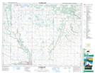
Maps showing Kite Lake, 17-18-W, Manitoba
Kite Lake is a Lake located in 17-18-W, Manitoba and has an elevation of 616 meters.
- Latitude: 50° 26' 41'' North (decimal: 50.4447000)
- Longitude: 99° 57' 0'' West (decimal: -99.9500000)
- Topography Feature Category: Lake
- Geographical Feature: Lake
- Canadian Province/Territory: Manitoba
- Elevation: 616 meters
- Location: 17-18-W
- Atlas of Canada Locator Map: Kite Lake
- GPS Coordinate Locator Map: Kite Lake Lat/Long
Kite Lake NTS Map Sheets