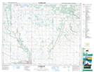
Maps showing Largs, 8-15-18-W, Manitoba
Largs is a Unincorporated area located in 8-15-18-W, Manitoba and has an elevation of 586 meters.
- Latitude: 50° 16' 1'' North (decimal: 50.2669000)
- Longitude: 99° 55' 45'' West (decimal: -99.9292000)
- Topography Feature Category: Unincorporated area
- Geographical Feature: Railway Point
- Canadian Province/Territory: Manitoba
- Elevation: 586 meters
- Location: 8-15-18-W
- Atlas of Canada Locator Map: Largs
- GPS Coordinate Locator Map: Largs Lat/Long
Largs NTS Map Sheets