Canada Topographic Maps

Laurie River Topo Maps

Topography maps and Latitude/Longitude Location

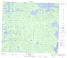
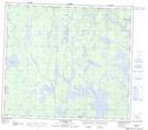
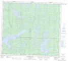
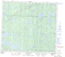
Maps showing Laurie River, 83 - 20W, Manitoba

Laurie River is a River located in 83 - 20W, Manitoba and has an elevation of 270 meters.

  • Latitude: 56° 12' 35'' North   (decimal: 56.2097000)
  • Longitude: 100° 36' 46'' West   (decimal: -100.6128000)
  • Topography Feature Category: River
  • Geographical Feature: River
  • Canadian Province/Territory: Manitoba
  • Elevation: 270 meters
  • Location: 83 - 20W
  • Atlas of Canada Locator Map: Laurie River
  • GPS Coordinate Locator Map: Laurie River Lat/Long

Laurie River NTS Map Sheets

064C02 Wheatcroft Lake Topographic Map at 1:50,000 scale

064C03 Mcknight Lake Topographic Map at 1:50,000 scale

064C06 Kadeniuk Lake Topographic Map at 1:50,000 scale

064C11 Mcgavock Lake Topographic Map at 1:50,000 scale

064C12 Laurie Lake Topographic Map at 1:50,000 scale

064C Granville Lake Topographic Map at 1:250,000 scale

 
Buy Topographic Maps DVD
Newsletter Sign-up

Yes, I want to receive map store discounts.


Bookmark and Share