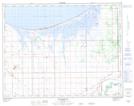
Maps showing Lavallee Creek, 14-6-W, Manitoba
Lavallee Creek is a River located in 14-6-W, Manitoba.
- Latitude: 50° 12' 5'' North (decimal: 50.2014000)
- Longitude: 98° 10' 55'' West (decimal: -98.1818999)
- Topography Feature Category: River
- Geographical Feature: Creek
- Canadian Province/Territory: Manitoba
- Location: 14-6-W
- GPS Coordinate Locator Map: Lavallee Creek Lat/Long