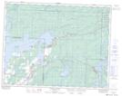
Maps showing Lee River Provincial Recreation Park, Manitoba
Lee River Provincial Recreation Park is a Conservation area located in Manitoba.
- Latitude: 50° 16' 56'' North (decimal: 50.2822000)
- Longitude: 95° 51' 46'' West (decimal: -95.8628000)
- Topography Feature Category: Conservation area
- Geographical Feature: Provincial Recreation Park
- Canadian Province/Territory: Manitoba
- GPS Coordinate Locator Map: Lee River Provincial Recreation Park Lat/Long
Lee River Provincial Recreation Park NTS Map Sheets