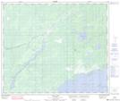
Maps showing Limestone Rapids, 12-61-11-W, Manitoba
Limestone Rapids is a Rapids located in 12-61-11-W, Manitoba.
- Latitude: 54° 16' 0'' North (decimal: 54.2667000)
- Longitude: 98° 59' 58'' West (decimal: -98.9993999)
- Topography Feature Category: Rapids
- Geographical Feature: Rapids
- Canadian Province/Territory: Manitoba
- Location: 12-61-11-W
- Atlas of Canada Locator Map: Limestone Rapids
- GPS Coordinate Locator Map: Limestone Rapids Lat/Long
Limestone Rapids NTS Map Sheets