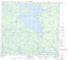
Maps showing Lucas Lake, 90-18-W, Manitoba
Lucas Lake is a Lake located in 90-18-W, Manitoba and has an elevation of 297 meters.
- Latitude: 56° 48' 47'' North (decimal: 56.8130999)
- Longitude: 100° 16' 36'' West (decimal: -100.2767000)
- Topography Feature Category: Lake
- Geographical Feature: Lake
- Canadian Province/Territory: Manitoba
- Elevation: 297 meters
- Location: 90-18-W
- Atlas of Canada Locator Map: Lucas Lake
- GPS Coordinate Locator Map: Lucas Lake Lat/Long
Lucas Lake NTS Map Sheets