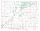
Maps showing Melita, 1-4-27-W, Manitoba
Melita is a Town located in 1-4-27-W, Manitoba and has an elevation of 428 meters.
- Latitude: 49° 16' 5'' North (decimal: 49.2680999)
- Longitude: 100° 59' 45'' West (decimal: -100.9957999)
- Topography Feature Category: Town
- Geographical Feature: Town
- Canadian Province/Territory: Manitoba
- Elevation: 428 meters
- Location: 1-4-27-W
- Atlas of Canada Locator Map: Melita
- GPS Coordinate Locator Map: Melita Lat/Long