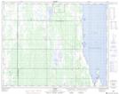
Maps showing Millers Point, 5,8-29-12-W, Manitoba
Millers Point is a Cape located in 5,8-29-12-W, Manitoba and has an elevation of 258 meters.
- Latitude: 51° 27' 55'' North (decimal: 51.4652999)
- Longitude: 99° 6' 58'' West (decimal: -99.1160999)
- Topography Feature Category: Cape
- Geographical Feature: Point
- Canadian Province/Territory: Manitoba
- Elevation: 258 meters
- Location: 5,8-29-12-W
- Atlas of Canada Locator Map: Millers Point
- GPS Coordinate Locator Map: Millers Point Lat/Long