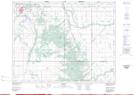
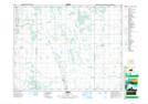
Maps showing Mink Creek, 9-15-14-W, Manitoba
Mink Creek is a River located in 9-15-14-W, Manitoba.
- Latitude: 50° 15' 31'' North (decimal: 50.2585999)
- Longitude: 99° 20' 28'' West (decimal: -99.3410999)
- Topography Feature Category: River
- Geographical Feature: Creek
- Canadian Province/Territory: Manitoba
- Location: 9-15-14-W
- Atlas of Canada Locator Map: Mink Creek
- GPS Coordinate Locator Map: Mink Creek Lat/Long
Mink Creek NTS Map Sheets