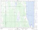
Maps showing Olsons Point, 17,20-28-12-W, Manitoba
Olsons Point is a Cape located in 17,20-28-12-W, Manitoba and has an elevation of 254 meters.
- Latitude: 51° 24' 21'' North (decimal: 51.4057999)
- Longitude: 99° 6' 26'' West (decimal: -99.1072000)
- Topography Feature Category: Cape
- Geographical Feature: Point
- Canadian Province/Territory: Manitoba
- Elevation: 254 meters
- Location: 17,20-28-12-W
- Atlas of Canada Locator Map: Olsons Point
- GPS Coordinate Locator Map: Olsons Point Lat/Long