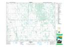
Maps showing Reeve, 13-20-15W, Manitoba
Reeve is a Unincorporated area located in 13-20-15W, Manitoba and has an elevation of 293 meters.
- Latitude: 50° 43' 7'' North (decimal: 50.7185999)
- Longitude: 99° 24' 55'' West (decimal: -99.4153000)
- Topography Feature Category: Unincorporated area
- Geographical Feature: Locality
- Canadian Province/Territory: Manitoba
- Elevation: 293 meters
- Location: 13-20-15W
- Atlas of Canada Locator Map: Reeve
- GPS Coordinate Locator Map: Reeve Lat/Long