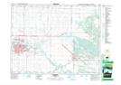
Maps showing Riverheights, Manitoba
Riverheights is a Unincorporated area located in Manitoba and has an elevation of 386 meters.
- Latitude: 49° 50' 43'' North (decimal: 49.8452999)
- Longitude: 99° 59' 31'' West (decimal: -99.9918999)
- Topography Feature Category: Unincorporated area
- Geographical Feature: Neighbourhood
- Canadian Province/Territory: Manitoba
- Elevation: 386 meters
- Atlas of Canada Locator Map: Riverheights
- GPS Coordinate Locator Map: Riverheights Lat/Long