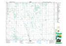
Maps showing Robins Ridge, 16,17-13-W, Manitoba
Robins Ridge is a Mountain located in 16,17-13-W, Manitoba.
- Latitude: 50° 26' 16'' North (decimal: 50.4378000)
- Longitude: 99° 11' 58'' West (decimal: -99.1994000)
- Topography Feature Category: Mountain
- Geographical Feature: Ridge
- Canadian Province/Territory: Manitoba
- Location: 16,17-13-W
- Atlas of Canada Locator Map: Robins Ridge
- GPS Coordinate Locator Map: Robins Ridge Lat/Long