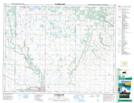
Maps showing Sandersons Creek, 13-15-18-W, Manitoba
Sandersons Creek is a River located in 13-15-18-W, Manitoba.
- Latitude: 50° 16' 48'' North (decimal: 50.2799999)
- Longitude: 99° 49' 52'' West (decimal: -99.8310999)
- Topography Feature Category: River
- Geographical Feature: Creek
- Canadian Province/Territory: Manitoba
- Location: 13-15-18-W
- Atlas of Canada Locator Map: Sandersons Creek
- GPS Coordinate Locator Map: Sandersons Creek Lat/Long
Sandersons Creek NTS Map Sheets