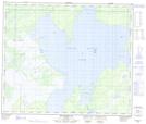
Maps showing Sandy Bay, 60-20-W, Manitoba
Sandy Bay is a Bay located in 60-20-W, Manitoba and has an elevation of 270 meters.
- Latitude: 54° 13' 37'' North (decimal: 54.2269000)
- Longitude: 100° 19' 55'' West (decimal: -100.3318999)
- Topography Feature Category: Bay
- Geographical Feature: Bay
- Canadian Province/Territory: Manitoba
- Elevation: 270 meters
- Location: 60-20-W
- Atlas of Canada Locator Map: Sandy Bay
- GPS Coordinate Locator Map: Sandy Bay Lat/Long
Sandy Bay NTS Map Sheets