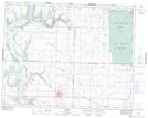
Maps showing Shellmouth, 32-22-29-W, Manitoba
Shellmouth is a Unincorporated area located in 32-22-29-W, Manitoba and has an elevation of 425 meters.
- Latitude: 50° 56' 5'' North (decimal: 50.9346999)
- Longitude: 101° 28' 45'' West (decimal: -101.4792000)
- Topography Feature Category: Unincorporated area
- Geographical Feature: Community
- Canadian Province/Territory: Manitoba
- Elevation: 425 meters
- Location: 32-22-29-W
- Atlas of Canada Locator Map: Shellmouth
- GPS Coordinate Locator Map: Shellmouth Lat/Long
Shellmouth NTS Map Sheets