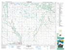
Maps showing Rolling River, 14,23-17-19-W, Manitoba
Rolling River is a Unincorporated area located in 14,23-17-19-W, Manitoba.
- Latitude: 50° 27' 20'' North (decimal: 50.4556000)
- Longitude: 99° 59' 10'' West (decimal: -99.9861000)
- Topography Feature Category: Unincorporated area
- Geographical Feature: Community
- Canadian Province/Territory: Manitoba
- Location: 14,23-17-19-W
- Atlas of Canada Locator Map: Rolling River
- GPS Coordinate Locator Map: Rolling River Lat/Long
Rolling River NTS Map Sheets