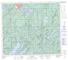
Maps showing Owl Creek, 4-76-3-W, Manitoba
Owl Creek is a River located in 4-76-3-W, Manitoba.
- Latitude: 55° 33' 30'' North (decimal: 55.5582999)
- Longitude: 97° 52' 19'' West (decimal: -97.8718999)
- Topography Feature Category: River
- Geographical Feature: Creek
- Canadian Province/Territory: Manitoba
- Location: 4-76-3-W
- Atlas of Canada Locator Map: Owl Creek
- GPS Coordinate Locator Map: Owl Creek Lat/Long