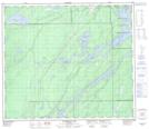
Maps showing Velde Creek, 15-74-5-W, Manitoba
Velde Creek is a River located in 15-74-5-W, Manitoba.
- Latitude: 55° 24' 31'' North (decimal: 55.4085999)
- Longitude: 98° 7' 53'' West (decimal: -98.1314000)
- Topography Feature Category: River
- Geographical Feature: Creek
- Canadian Province/Territory: Manitoba
- Location: 15-74-5-W
- Atlas of Canada Locator Map: Velde Creek
- GPS Coordinate Locator Map: Velde Creek Lat/Long
Velde Creek NTS Map Sheets