Maps showing Foures Island, 31-15-15E, Manitoba
Foures Island is a Island located in 31-15-15E, Manitoba.
- Latitude: 50° 18' 28'' North (decimal: 50.3078000)
- Longitude: 95° 31' 57'' West (decimal: -95.5325000)
- Topography Feature Category: Island
- Geographical Feature: Island
- Canadian Province/Territory: Manitoba
- Location: 31-15-15E
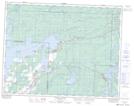
- Atlas of Canada Locator Map: Foures Island
- GPS Coordinate Locator Map: Foures Island Lat/Long
Foures Island NTS Map Sheets