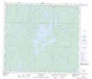
Maps showing Johnston Rapids, 89-18W, Manitoba
Johnston Rapids is a Rapids located in 89-18W, Manitoba.
- Latitude: 56° 43' 30'' North (decimal: 56.7249999)
- Longitude: 100° 14' 27'' West (decimal: -100.2408000)
- Topography Feature Category: Rapids
- Geographical Feature: Rapids
- Canadian Province/Territory: Manitoba
- Location: 89-18W
- Atlas of Canada Locator Map: Johnston Rapids
- GPS Coordinate Locator Map: Johnston Rapids Lat/Long
Johnston Rapids NTS Map Sheets