Maps showing McKay Hill, 116-13W, Manitoba
McKay Hill is a Mountain located in 116-13W, Manitoba.
- Latitude: 59° 4' 32'' North (decimal: 59.0756000)
- Longitude: 99° 39' 27'' West (decimal: -99.6575000)
- Topography Feature Category: Mountain
- Geographical Feature: Hill
- Canadian Province/Territory: Manitoba
- Location: 116-13W
- Atlas of Canada Locator Map: McKay Hill
- GPS Coordinate Locator Map: McKay Hill Lat/Long
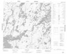
McKay Hill NTS Map Sheets